New links! If you look to the right, you will see a couple new html links. I created these using Google Maps. One map shows the Amnicon Falls State Park area (just East of Duluth-Superior--AKA The Twin Ports). The other shows the precise location of the Deep Water Grille in Ashland, Wisconsin, where the reception is. If you click on "List of Details for Wedding Go-ers" you will find written directions to both of these. Otherwise, you can just click on the maps, and you have the option to get directions from Google Maps itself.
I did not post a map to the Best Western or River Rock Inn in Ashland, WI. Both of those are on Lake Shore Drive (Highway 2), which is the main drag through town. If you want to check out the Ashland Best Western, click here: http://www.bestwesternlakesuperiorlodge.com/ This is the link for River Rock's website: http://www.riverrockinn.net/ Fair warning: the entire wedding party might be taking up the rooms at the River Rock Inn; it all depends on a few external factors. But, as I have posted on the Details list, there are many other hotels in the town: Super 8, AmericInn (on the east end of town), Hotel Chequamegon, and some cute B&Bs. Just browse for Ashland area lodging, and you will find lots of fun stuff!
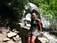
The Ceremony Site

Amnicon Falls Covered Bridge
No comments:
Post a Comment